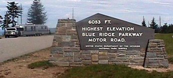
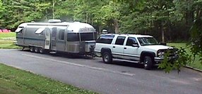
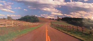
After ten days at home, we hit the road again - this time northward through the mountains to Franklin, North Carolina, then Sylva. Just past Sylva we got on the Blue Ridge Parkway. The morning was beautiful - the air clearer than I can ever recall it. As we climbed higher and higher, it appeared that we could see 100 miles out across the Smokies. The highest point on the parkway is 6,053 feet in elevation and well marked. Traffic on the parkway was light, as it almost always is. This is not the way to travel if one is in a hurry. It took an hour and a half to go the first 35 miles, but there just isn't a prettier drive any where. Mountain laurel and flame azalea were still in profusion in the higher elevations, and the catawba rhododendrum was just beginning to bloom. There were places where all three were intermingled.
We pulled into the campground a Mt. Pisgah about 12:30pm, got set up and went down to the Mt. Pisgah Inn for lunch. The campground is run by the National Park Service. With our Golden Age Passport, the fee was a whopping $6.00 per night. We were at 5,000 feet, nestled in a thicket of rhododendrum and mountain laurel under a canopy of oaks - temperature in the 60s. This spot was once a part of the Biltmore Estate.
Wednesday, June 6, 2001
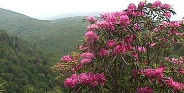
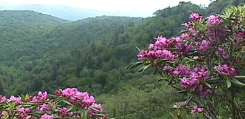
We hooked up early for the day's ride up the parkway. This was probably the fourth or fifth time we've driven the Blue Ridge Parkway, but never before at this time of year. The blooming rhododendrum, mountain laurel, and flame azaleaa really made for a spectacular setting. We agree that of all the trips this one has been the most enjoyable because of the floral beauty. The clear weather was a plus too. These flowering shrubs appear to peak at different times in different locations. In some spots the mountain laurel was just beginning; in others it was past peak - same with the rhododendrum. All the park magazines say that mid-June is the peak time for the rhododendrum. If that's true, it will peak in most places in another week or so. Still, what we've seen has really been awesome and breathtaking.
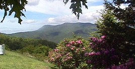
We stopped for lunch at Crabtree Meadows. The campground there looked to be very nice, but it was to early to stop. The roadway follows the ridge of the mountains as much as possible, affording great views on either side, especially in the higher elevations. There was not much to see in the lower elevations because the trees were too thick to see out, but the new green foliage made that pretty too. The route was up and down, from 5,000 feet to 3,000 feet and back, passing through a dozen or more tunnels.
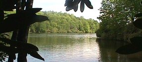
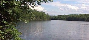
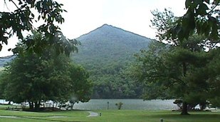
We stopped for the evening at the Julian Price Memorial Park campground, just north of Grandfather Mountain. The campground borders a large lake. There were only a few sites that were large enough for our trailer. The sites are assigned on a first come, first served basis, so it paid to stop early.
After unhitching, we drove about fifteen miles down a winding narrow road into the little town of Valle Cruces, near Boone. Ann wanted to see the original Mast General Store. The store has been there since the late 1800s, offering just about everything imaginable. Ann had a Nehi orange drink while I found an RC Cola and a moon pie. I bought a dollar's worth of marbles out of a bulk barrel, and little else.
Back on the parkway, we stopped at the Moses Cone house, an old mansion with a 180 degree view of the valley and mountain ranges to the east. Moses Cone was a successful businessman from Tennessee who acquired this mountain property in the latter part of the 19th century. The house was built around 1900 and was left to the National Park Service in 1950.
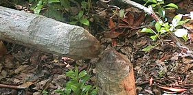
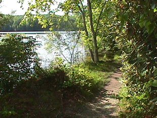
Feeling the need for a little exercise, I started out walking on what looked like an easy, paved trail down to Price Lake. I soon discovered that I was on a 2.3 mile loop trail that went around the whole lake. Rather than turn back, I continued around, snapping a few pictures as I went. The paved portion soon ran out, and I was scrambling over roots through thick stands of rhododendrum, catching a glimpse of the lake every now and then. At places there was gravel on the trail, at other places a boardwalk, and at others just mud. I met a few other hikers and saw several fishermen trying their luck in the lake. At one point there was clear evidence of beaver activity as shown in one of the pictures below. The loop took about an hour.
Thursday, June 7, 2001
Spoiled by two days of brilliant sunshine, we awoke to a rainy, overcast day. It didn't take long to get hitched up and back on the Parkway. The rain was intermittent, and the air was still exceptionally clear. In the muted light, the mountains looked to be a deep blue color, lighter in shade on each range farther distant, giving credance to their name - the Blue Ridge.
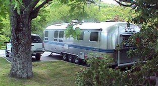
The further north we travelled, the less steep were the grades, and the less spectacular the scenery, though it was still pretty. We were still climbing and descending with the ridge, but now it was only between 3,000 feet and 4,000 feet. There was more mountain laurel blooming than anything else in the section between Blowing Rock and Rocky Knob where we stopped for the evening. The campground at Rocky Knob is much like the others - designed back in the 1930s for tents and small trailers. Only a few sites were large enough for our 34 foot Airstream. This campground was not crowded though, and we found a sutiable site.
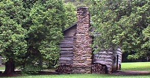
Here's some history of the Blue Ridge Parkway. During the depression days of the early thirties, President Roosevelt was seeking ways to put men to work. He initiated the Civilian Conservation Corps, then looked for projects for the men to undertake. Building a road along the ridge of the Great Smoky Mountains was probably the most ambitious of all the make work projects the CCC attempted. The 469 miles from the Shenandoah Valley of Virginia to Cherokee, North Carolina crosses some of the most rugged terrain in the country. Construction began in 1935, with the last section completed in 1987 That last link was called the Linn Cove Viaduct around Grandather Mountain and at the time was the most expensive roadway ever built in terms of cost per lineal foot. The engineers called it a "superrelegated reverse spiral curve," supported by precast cantilevered beams anchored to the mountainside. That last section was decades coming as all sorts of environmental problems had to be overcome. Overall, the civil engineers and landscape architects did a magnificent job on the parkway. With strategically placed parklike overlooks, picnic areas, campgrounds, preserved homesteads, and split rail fencing, it is an enjoyable place to be - and it is well maintained and very clean. One must come to the parkway to enjoy the parkway though, not to get from point A to point B in a hurry. There are nine campgrounds - five in North Carolina and four in Virginia. A great vacation would be to just go from one campground to another, spending a couple of days in each.
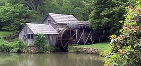
We made a stop at the Northwest Trading Post (which is being remodeled and enlarged) and at Mabry Mill for lunch before pulling into the campground at Rocky Knob.
Friday, June 8, 2001
With deteriorating weather we broke camp again and headed north. Intermittent rain and low clouds made it harder to see. The haze, more typical of the mountains, had also settled in. This section of the parkway is even lower in elevation. The grades and curves were much more gentle as we ranged from 3,000 feet down to 1,200 feet - the lowest being near Roanoke, Virginia.
A new Visitors Center has been added near Roanoke which also includes a site called Virginia's Explorer Park. This would make a good stop in good weather. The park illustrates and dramatizes life in Virginia during three different periods of the past. We stopped at the Visitors Center, but did not do Explorer Park because of the rain.
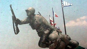
Our destination for the day was the campground at Peaks of Otter. After setting up, we drove over to the lodge for lunch, then into the town of Bedford. Bedford is the home of the new DDay Memorial, dedicated just two days ago by President Bush. The dedication took place on the 57th anniversary of the landing - June 6, 1944. There were several thousand people there even though the park was not quite finished. Statues depicting the landing on Normandy Beach - called Operation Overlord - show troops wading ashore through the water with shells splashing all around them, then climbing a rock cliff amidst enemy fire. Bedford was chosen as the location of the memorial because there were more DDay casualties per capita from Bedford,Virginia than from any other place in the country.
Saturday, June 9, 2001
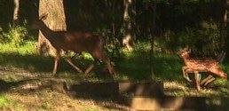
This morning, when I opened the trailer's door, within twenty feet there was a doe and a pair of spotted twin fawns. They took a look at me, then casually strolled back into the woods. All the clouds disappeared during the night. After a couple of days of mostly rain, the sun was a welcome sight.
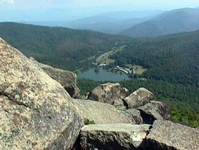
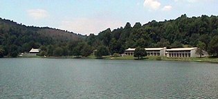
We caught the 10:00am bus up the old CCC road to Sharp Top, one of the two "Peaks of Otter." From the end of the road, we climbed the remaining 1500 feet to the top on foot. The rocky pinnacle afforded a 360 degree view of the countryside from an elevation of 3,875 feet.
Despite bright shunshine, the haze that settled in a few days ago was still very much in evidence. Still the views from Sharp Top Mountain were very nice. The lake and lodge were clearly visible down below. Some of the rock from Sharp Top was used in the Washington Monument. The other "Peak of Otter" is Flat Top Mountain, actually 126 feet higher than Sharp Top. The morning was gone by the time we got back down.
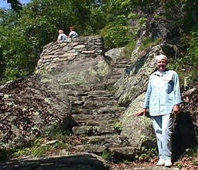
After lunch we walked the 1.3 mile trail around the lake - Abbott Lake - from which there was a good view of Sbarp Top Mountain from below and the Peaks of Otter Lodge. At the end of the walk we stopped in the coffee shop at the lodge for some pie and icecream.
Sunday, June 10, 2001 -
The parkway was almost deserted as we left camp early, headed for Scottsville, Virginia and a visit with the Schumakers (Ann's sister and brother-in-law). The elevation dropped from 3,000 feet down to less than 1,000 feet in about 12 miles as we coasted all the way. We left the parkway on Virginia Byway US130, heading east to US20, then north to Va6, then east to Scottsville.
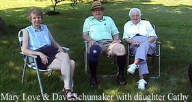
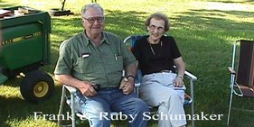
Dave and Mary Love had come down to their Scottsville property from Charlottesville to camp with us there. While visiting with them their daughter came for lunch, then Dave's brother Frank and wife Ruby joined us.
During the afternoon we all rode out to the old Schumaker home place, now all grown over. Dave showed us where he grew up and went to school.
Monday, June 11, 2001
Spent the day with Dave and Mary Love Schumaker in Scottsville. Unfortunately, Dave's sister and our dear freind, Millie Ransone, passed away on Sunday. Family members are gathering to go to Florida for the funeral. There was lots of uncertainty about the arrangements. Many members of her family are going to Florida from Virginia for the funeral.
Tuesday, June 12, 2001
We moved over to Pocahontas StatePark near Chesterfield, Virginia, both to get out of the Schumaker's way in view of their plans to attend Millie's funeral and to beat some anticipated rain. As it turned out the rains never came, though we heard horror stories of floods from Texas through Georgia and South Carolina.
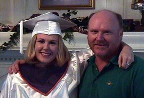
We found the John Bergs very active. All the children were home with the main focus on Bonnie and her pending graduation from Manchester High School. Bonnie is starting college immediately - Longwood - to get a head start on her pre-med course. John, Jr. was a couple of weeks away from attending Virginia Tech for a summer school session of chemistry and calculus before returning to VMI for his second year. Jordan was in her last week of the second grade. Barbara's mother, Louise Westfall, was there from Brandon, Florida for the occasion. John was home for the week. He's been commuting weekly to Tulsa, Oklahoma where his company, Cogentrix, Inc., is getting a new power plant on line.
Bonnie and Dad
Friday, June 15, 2001
We left Pocahontas State Park early for the 475 mile trip home. That's further than I like to drive in one day, but it was time to get home. We found everything just as we left it.