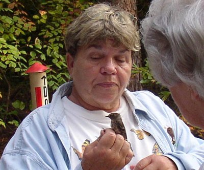
October 12, 2006 - After just one night at the Kiptopeke State Park, we moved on, but not before accepting an invitation from a local camper to observe a bird banding procedure back in the woods in the park. The banding station is set up under a shelter, while the people volunteering to collect the birds walk a couple hundred yards along a six-foot verticle net. The little birds can't see the netting and fly into it where they are trapped. The volunteers remove the birds, handling them carefully. On the walk we accompanied, they caught three small warblers. They took the birds back to the banding station where tiny aluminum numbered tags were attached loosely to their legs. Their weight, wingspan, species, and age were recorded, and they were then released. Other stations around the migration route do the same thing. If they catch a bird that already has a band, they can tell where the bird came from and whether it was flourishing. Their goal is to find ways to improve the bird's habitat.
We again crossed the Chesapeake Bay on the bridge/tunnel complex, this time southbound, proceeding on to the Outer Banks of North Carolina. Near the old village of Chincamacomico - now Rodanthe - we camped at Camp Hatteras, actually at Waves, North Carolina. This was a first class campground with full hookups, including concrete pads and WiFi. Not long after settling in, we all went down to the old Life-Saving Station at Chicamacomico where again we heard the story of the surfmen who risked their lives to save the victims of shipwrecks. It is a shame that this heroic activity is so little known. So many lives were being lost back in the 1800s along the coast, the Federal government started the life-saving service in 1871. The first station at Chicamacomico was built in 1874. Seven of the old buildings here have been restored, and interpreters tell the dramatic story. From 1871 until 1915 the surfmen were successful in saving 177,000 lives, only failing to save about 1,000 in that entire period. It's quite a story of heroism in miserable conditions.
The surf boat used at the lifesaving station was manned by eight oarsmen. Getting that boat that weighted thousands of pounds to the waters edge must have been a real chore, then launching it into heavy surf had to be daunting. The surfmen literally put their own lives at risk in the storms to make all those rescues. The boat was of a unique design. It was self bailing and would right itself when turned upside down in the waves. The crews practiced walking the keel when it was in the process of righting itself. It was amazing that no surfman was ever lost at the Chicamacomico station.
That evening we enjoyed a "clambake" in the campground activities room. The meal, cooked in the kitchen of the activities room, included clams in the shell, corn on the cob. potatoes, and bread. The meal was followed by a few joker games. At our table were Jerry and Mary Arnold from Tennessee and ourselves. The Robinsons and the Wengers were at another table.
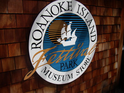
October 13, 2006 - Cooler this morning, we had a day to explore on our own. Roanoke Island, Hatteras Island, Okracoke Island - all names along the thin strip of sand called the Outer Banks of North Carolina. Roanoke Island, actually a larger island lying between the outer islands and the mainland, is the site of the first English speaking colony in America. Roanoke Island has the further distinction of being the birthplace of the first English baby in America. Virginia Dare was born on August 18, 1587. The first group of Englishmen to land on Roanoke Island disappeared without a trace. The story of the Lost Colony is told in America’s oldest outdoor drama during the summer months. The story is also well told at the Roanoke Island Festival Park for which we had caravan tickets. This is a first class exhibit , that tracks the 400 year history of Roanoke Island, including boat building, shipwrecks, pirates, Civil War involvement, the Freedman village, as well as the Lost Colony. A film told the story of local Indians and their relationship with the newly arrived foreigners. Modern day Dare County derives its name from Virginia Dare.
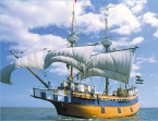
One highlight at the festival park is the Elizabeth II, a replica of the 16th century sailing vessel that brought those first English colonists to these shores. It's tough to imagine how 50 persons could have made the long voyage across the Atlantic Ocean in such a small and fragile vessel. There were 24 crewmen - 12 on duty at any given time - along with 25 others who were carpenters and other craftsmen coming to makeup the colony. Loose items on the small boat were being secured for a three day demonstration voyage around the bay area.
The next stop was the North Carolina Aquarium. A young man was lecturing on sharks as we arrived. We walked through the various fish displays. It was very nice, but not anywhere near the scale of the new Georgia Aquarium in Atlanta. The shark man did mention the whale sharks in Atlanta.
Sid and Sarah Watters were with us, and after a light lunch at McDonalds, we came back to camp. In the evening we had our fifth GAM with Keith and Gail Mahler, Dave and Sue Wendt, Art and Carol Hall, and us.
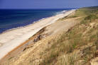
October 14, 2006 - More than 70 percent of Hatteras Island remains in its natural barreir island state due thanks to the Cape Hatteras National Seashore and the Pea Island National Wildlife Refuge. The shifting sand of the dunes between the road and the beach blocks the view of the ocean from motorists traveling down the road. To gain access to the beach, one must climb through the deep sand up and over the dunes. At low tide the beach is a hundred yards wide, At high tide there is little beach as the waves can reach the dunes. At places outside the Federal lands stairs have been built to make the trek to the beach a bit easier, though it can still take some effort.
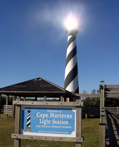
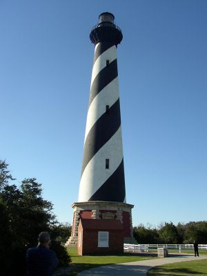
The Cape Hatteras lighthouse is probably the best known manmade feature on Hatteras Island. Threatened by beach erosion, the lighthouse was moved 3200 feet inland in 1999 to its present location. Completed in 1870, the Cape Hatteras light is 208 feet in height and is the tallest brick lighthouse in the United States. Its first order Fresnel lens can be seen 20 miles at sea. That had to be a monumental task moving such a massive structure. It was closed for the season, so we couldn't go inside, but the impressive views are from the outside anyway. Caught the sun reflecting in the lighthouse windows in the picture.
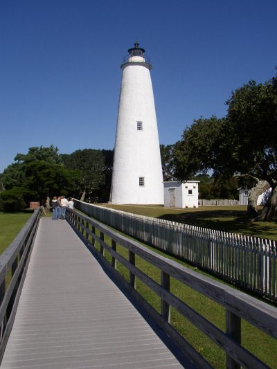
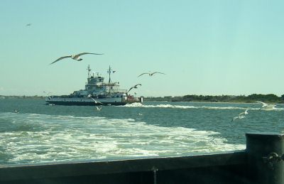
From the lighthouse, it was but a short drive to the ferry docks for the 40 minute ferry ride to Ocracoke Island. We had hoped to see some of the wild ponies still on Ocracoke, but none were visible. We visited the Ocracoke lighthouse. It is not nearly as tall as the Hatteras light, but it is about 50 years older, having been built in 1823. There's not much on Ocracoke beside the lighthouse and ferry docks and a lot of sand. Their one claim to fame is that Ocracoke was the home of Blackbeard the Pirate. Found a nice restaurant in Ocracoke City for lunch, then reversed the drive back to the campground.