Sunday, October 1, 2000 - At the close of the Sugarcreek rally, 27 Florida bound trailers and motorhomes gathered to begin a caravan through the southern Appalachian mountains. Jerry and Ellen Honaker were our leaders. Our first stop was Morgantown, West Virginia, a 200 mile drive from Sugarcreek. Taking Interstates I-77, I-70, I-79, and I-68, we traveled through Ohio, West Virginia, Pennsylvania, then West Virginia again to reach the Sand Springs Campground east of Morgantown. The mountains were beginning to show a little color of Fall. It was a beautiful day and an easy drive, though the grades were steep in places. Everyone was in camp by 4:00pm.
isabelle Sides immediately organized several "GAMs" - get acquainted meetings. So, at 4:30pm 6 or 7 couples gathered at designated campsites to introduce each other and share some snacks. We hosted one of the GAMs and built a campfire to gather around. Two of our couples were from Canada, one was from New York, one from Ohio, one from Florida, and us from Georgia - the Charboneaus, the Kvists, the Weekleys, the Haaks, the Honakers, and the Bergs. Then, at 7:00pm we all went down to the campground dining room for a chili supper and drivers' meeting for the next day. It was at the drivers' meeting that our leader informed us that West Virginia was the largest state east of the Mississippi River --- if you laid it out flat.
Monday, October 2, 2000 - This was another travel day through West Virginia, Maryland, and into Pennsylvania to Gettysburg. Dropping from an elevation of about 3,000 feet to about 500 feet, we came through some pretty rugged countryside - steep grades and sharp curves. Yet, the scenery was very nice. In Maryland, the fall colors were especially striking. Much of the trip was through pretty dense fog, but when we climbed to the high passes we rose above the fog, and that's when the colors were so vivid. We travelled 174 miles this day. Dinner was a General Pickett's Buffets, an especially good meal and rally treat.
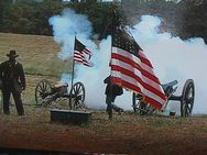
Tuesday, October 3, 2000 - Culp's Hill, Cemetery Hill, Seminary Ridge, Big Round Top, Little Round Top, McPherson Ridge - all names forever etched into the history of the country on the first three days of July, 1863 - all battle sites in the pivotal battle of the Civil War. Although the fighting continued for two more years, Gettysburg was where the tide of war changed. Had a simple decision here or there been different the Confederaacy could have prevailed. Perhaps it was providential that they lost. It can only be speculated what would have happened had the outcome been different. The fact was that the Union army won at Gettysburg and the Union remained in tact. But at what a cost! 51,000 men lost their lives in the Battle of Gettysburg - 28,000 Confederates and 23,000 Union soldiers. The more than 5,000 horses that were killed added to the carnage.
We boarded a double decker bus at noon to tour the battlefield. There was very little conversation as we walked around Little Round Top and rode down Cemetary Ridge. The somber awareness of the bloodshed that occurred in those places was on everyone's mind. The bus drove a 23 mile loop through the area, stopping several times at significant spots. Each seat on the bus was equipped with headphones to listen to the taped narration that described the various battles. The tour ended as we rode by the cemetery accompanied on the headsets by a rendition of Lincoln's 1863 dedication - The Gettysburg Address.
Wedesday, September 3, 2000 - Carpooling to Harper's Ferry, we left camp at 8:00am on the dot for the 45 mile drive. It was a beautiful day - warm and sunny. The convoy was about 15 vehicles long. Upon arrival at the Visitors Center, we immediately boarded a shuttle bus to go down into the old "Lower Town" area which is now a National Historic Park.
Located at the confluence of the Shenandoah and Potomac Rivers on the northeast tip of West Virginia, Harpers Ferry is in a beautiful setting. Rugged mountains surround the town. The rangers claim that the "Industrial Revolution" began here. At the end of the 18th century the new nation needed an arms manufacturing facility. Harpers Ferry was chosen. In the next fifty years it became a highly industrialized community with the first application of the idea of interchangeable parts for rifles. A federal stockpile of guns and ammunition was stored here. It was that stockpile that attracted John Brown and his raiders in 1859.
John Brown thought that he could steal all those rifles and arm the slaves so they could free themselves. His raid took the town by surprise, and he actually held control for 36 hours. Then the marines came and stormed the old fire house where he had holed up. Several of his men were killed, and Brown was captured. He was tried for treason and hanged in the nearby town of Charles Town. When news of his execution reached his abolitionist friends in the north, John Brown became a martyr to the cause of freeing the slaves. He also became the catalyst that led to secession and the Civil War two years later. We heard that Stonewall Jackson brought a corps of VMI cadets in to witness the hanging and guard against disruption.
Because of the armory, Harpers Ferry was a prize sought by both Union and Confederacy during the war. Control of the town was exchanged eight times. The war so devastated the citizenry, that the civilian population dwindled from 3,000 to a couple hundred. Subsequent flooding wiped out any rebuilding effort after the war, and Harpers Ferry became a ghost town until the Park Service came in during modern times.
The Appalachian Trail goes directly through the old town of Harpers Ferry and crosses a footbridge that parallels the railroad tracks to Maryland on the other side of the Potomac.
We walked through the streets of the old town, visited some museums, listened to a park ranger program, and ate lunch before driving back to camp.
Thursday, October 5, 2000 - It was moving day again as the caravan headed south to Boyer Station, West Virginia. Unfortunately the Schumakers felt it necessary to leave the caravan and head home. We proceeded south into West Virginia through some of the ruggedest countryside yet. SR7 across the mountains was steep and curvy (many grades of 9%), but the scenery was outstanding. The road reached elevations of nearly 4,000 feet and dipped to 2,000 feet - several times. Fall colors were brilliant - probably near peak in the higher elevations. The last 50 miles, we were driving through a foliage tunnel with the sun shining through the leaves in a manner that created an absolutely gorgeous effect. The gold, yellow, orange and red colors were brilliant.
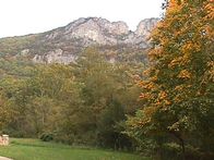
We made a stop at a place called Seneca Rocks - a sheer rock cliff rising a thousand feet above the valley. Many rock climbers were working their way up the vertical face of the cliff. They were small white dots visible with the naked eye, but only recognizable as men through binoculars. Maple trees around the valley floor with their brightly colored leaves set off the mountainous rock in a beautiful way. There was an old house that had been restored - once the home of a pioneering farmer. What a spot he had found to establish his homeplace!
The caravan ate together at the campground restaurant.
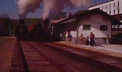
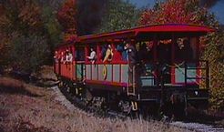
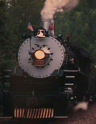
Friday, October 6, 2000 - Today we rode on the Cass Scenic Railroad from Cass to Bald Knob, the second highest mountain in West Virginia - 4,842 feet elevation. The day was overcast and cool. The popular excursion train was pushed and pulled slowly by two Shay steam engines along a steep railway with grades up to 15%. The Shays were uniquely designed with direct drive gears to each wheel for the power to pull such steep grades with heavy trainloads of logs. Those engines have been running since the early part of the 20th century in the logging operation. The run from Cass to the mountaintop is eleven miles long with two switchbacks. There was one stop at a clearing called Whitaker Station where coffee and hot chocolate were a welcome refreshment. Fall foliage was at peak color - possibly a little beyond peak.
It took four tons of coal for the engines to push the nine cars up the eleven miles. Coming down was all by gravity with the brakemen on each car controlling the speed. The round trip took about five hours. Had the sun been out it would have been warmer and the foliage more brilliant, but it was nonetheless a good day.
The down side of the trip was the fog and damp chill at the mountaintop. We were in the clouds and unable to see one end of the train from the other, much less the panoramic scenery that would otherwise have been viewable
from the observation deck.
Cass was once a company-owned town - built to house the lumbermen that logged the mountain and those who worked in the saw mills. It is now a state park. The logging and mills shut down in 1960 after sixty years of operation. The mountainsides had been cleared of the red spruce trees that made all that effort possible. The white houses in the town, most alike and abandoned, are being restored as vacation cottages for modern tourists.
Upon our return to the campground, we had another meal together at the campground restaurant, and afterwards were treated to entertainment by a local country singer singing to Karioka(?) music.
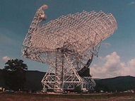
Saturday, October 7, 2000 - The sun was out again when we started the day with a trip to the National Radio Astronomy Observatory about three miles up from our campground. This facility is listening to sounds from outer space with huge parabolic telescopes. The largest, just finished, is 300 feet in diameter and weighs 17 million pounds. It can be accurately aimed at objects in space millions of light years away. The young lady who conducted the tour was very knowledgable and able to well describe what was going on. After a 30 minute talk and slide show, we boarded a bus for a tour of the grounds - all very impressive. The Greenbank valley was chosen for its isolation and lack of electronic interference.
After the Greenbank tour we went back to the campground and picked up the trailer for the trip to Beckley. The roads out of the valley were hilly and crooked, although there were no more of the extreme grades. With fall colors in all directions, and with the sun out, the drive was a very nice one.
At Beckley we stopped for lunch and some browsing at the Tamarack, a display of West Virginia crafts that was very unusual.
Sunday, October 8, 2000 - The day began with church services at the laundry room of the campground. Don Sides led the service with a light sermon, and there were some songs. After lunch we met at the Tamarack at 1:00pm for a convoy to the New River Bridge.
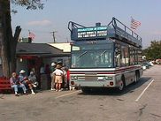
The name Tamarack comes from a tree by the same name - a deciuous tree native to the eastern highlands of West Virginia. It was used in the coal mines for support timbers, and is used for flooring and furniture. Because its strength, versatiliy and beauty are the characteristics the natives ascribe to West Virginia, the name was chosen for the facility that shows off the products of West Virginia. The craft items on display and for sale are remarkable. Prices range from a few dollars to several thousand dollars. A coffee table with a glass top imbedded with the brass sculpture of a dog swimming with his head above the glass and body below was priced at $14,500.00. The dog had a bird in its mouth as if it were retrieving it after a kill. There were fish swimming below the glass surface. This wasn't the most expensive piece. We didn't see any buyers, but there were hundreds of people going through the exhibits. The Tamarack was a great place to visit.
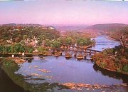
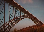
The New River Bridge is an engineering and construction masterpiece. It is the largest arch bridge in the world. Located about 20 miles east of Beckley, it crosses the New River Gorge and river at a point where the gorge is over 3,000 feet wide. From the center of the span down to the River is 876 feet. The steel in the bridge weighs 44 million pounds. The most remarkable thing about the bridge is the way it was built. A helicopter carried a lightweight cable across the gorge to begin with. Then increasingly heavier cables were pulled across. From these cables the pieces of the steel arch were moved into place, starting at borh ends and working toward the center. When the two sides met, and the last piece of steel was put in place, all the cable supports were removed and the arch became self supporting. All the parts were manufactured in a steel plant miles away with extreme precision for something so massive. After the arch was completed, the four-lane deck for the roadway was built on top of the arch. The result was this magnificent structure. Crossing the gorge made east-west transportation possible through the mountains. Prior to the the bridge construction (it was completed in 1977), any traffic had to descend a winding, twisting narrow road to the bottom of the gorge and cross a one-lane bridge, then do the same ascend on a similar road to the top again on the other side, an hour's worth of driving.
From the Visitor Center we drove the old road to the bottom, watched some whitewater rafters negotiating the rapids in the river, then drove the old road back up the other side. Views of the gigantic bridge from below were awesome. In this area, the foliage had barely started turning color. The elevation in the gorge is about 1,000 feet lower than the area around Greenbank where we were the day before.
After the bridge tour, we drove about 15 miles downstream to Hawks Nest State Park where our caravan leaders had arranged for an evening meal in a banquet room at the lodge there. Picture windows afforded a breathtaking upriver view of the gorge from that point. It was dark before we arrived back in camp for the night.
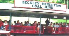
Monday, October 9, 2000 - This was a good day to spend underground. The temperature was in the low 30s with snow flurries in the air as we left camp, riding with Inabelle and Don Sides, heading for the coal mine. The Exhibition Coal Mine in Beckley was once a working mine with under-
ground shafts extending back seven miles into the mountain. The mine operated from 1890 until 1910. The vein of coal that was being mined was about three feet thick. Some 1500 feet of the mine have been shored up and restored for the exhibit.
We boarded the little train about 8:45am for the 45 minute tour. The guide had worked in a coal mine for 15 years and was very knowledgable about the procedures. In the early days the miners were treated and paid poorly for the backbreaking work. To extract the coal they had to use pick and shovel from a prone position to dig out a 4 foot by 4 foot space space under the coal seam. Then, after drilling four holes in the coal, blasting powder was inserted and fired. The coal then crumbled into the undercut and had to be shoveled by hand into small rail cars that were pulled to the outside with mules. The miners were paid by piece work - 20 cents per ton. Out of that they had to furnish all their own equipment and supplies, and had to pay the mule driver to take it out. Conditions were terrible. The ceiling of the tunnel was only five foot high. The air was foul and damp, and the only light was from carbide lamps mounted on their helmets. It's no wonder that John L. Lewis became their hero and savior with his United Mine Workers union.
When we emerged from the mine shaft, the skies had cleared and the sun was again shining. The caravanners ate together again at the K&W Cafeteria in the Crossroads Mall.
Sunday, October 15, 2000 - The campground provided and "all you can eat" breakfast this morning - pancakes, sausage, bacon, etc. We then had a church service in the upstairs meeting room. The rest of the day we were free to do as we pleased. A few of us decided to go back into the park for the hike to the top of Clingman's Dome. That proved to be not too tiring, so we tackled the much more challenging Chimney Tops. The views from bot pinnacles was outstanding. There were places scattered around the mountains where the leaf colors appeared to be at the peak. Though most of the mountains are still predominantly green. The air was not as clear as it was on Friday, but it was still nice.
The walk to the tower on Clingman's Dome is a half mile steady climb, but the trail is paved. The Fraser fir trees that used to adorn the 6600 foot mountain are now nothing but skeletons. A ranger explained that it was an insect called a Balsam Wooly Aplegid(Sp?) was the problem. A few small trees still show green, but they are probably doomed too. This is an insect that found its way to the U.S. from Europe - notably Germany. It started its destructive activity in this area in the 1950s.
Another problem was clearly visible from the top of Clingman's - the smog. To the west, there was a low lying layer of dirty air almost from as far as you could see, left to right. It was a bit depressing to realize that we had to go back down and breathe that stuff.
The climb to the Chimney Tops was exhilerating. That's a two mile hike up, then two miles back down again, climbing 1700 feet in the process. The first mile is an easy walk, then it begins to get steep. Near the top, we had to scramble over rocks and roots to make any progress. Then, at the very top, the trail disappears into steep rocks, and the only way to go up is to grab hold of roots or rock edges and scramble. But, after all that effort the views from the top are gorgeous - well worth it all. There's an almost 360 degree panorama. Getting down was almost as challenging as climbing up. There were only four of us venturesome enough to to it - Jerry Muller, Gary and Pat Kvist, and myself.
Monday, October 16, 2000 - This was our day to host the caravan in Hiawassee. We were camped in the Georgia Mountain Fair Campground on the shores of Lake Chatuge, arriving there in mid-morning from Cherokee. At 1:00pm we lined up for a convoy up to Brasstown Bald and a Forest Ranger presentation on the functions of the Forestry Service and a short history of the Cherokee Indians. He finished his presentation with a demonstration of a six foot long blow gun that the Cherokees used to hunt small game.
The leaf color on Brasstown Bald was outstanding - probably at its peak. Down in the lower elevations, it had hardly begun. The temperature was mild - near 70 degrees at the fire tower. After browsing the museum and observation deck we shuttled back to the parking lot and drove to Helton Creek Falls.
The falls were pretty, but the volume of water was down - presumably because of all the dry weather. A boardwalk and viewing deck has been built to make the last few yards of the hike down much easier. Still, some of the group had to get down and jump around on the rocks beneath the falls.
By the time we returned to camp it was time time to line up for the ride into Hiawassee for dinner at Daniel's Steak House. By the time that was over, everyone was tired from a full day.
Most of the caravanners continued on south to Florida. Since we were so close to home, we told everyone goodbye, and after an evening in the campground, made our way on home to our home in Young Harris.