After two days of being glued almost non-stop to the TV, watching the shocking events of the terrorist attack on the New York and Washington, we considered cancelling this trip. But there seemed to be no real reason to do that. Though stunned by the news, we decided to go ahead with the trip, praying as we did for the country. We left home about 8am working our way through Georgia, North Carolina, and Tennessee to I-75 at Sweetwater, Tennessee. The traffic on the interstate highway was heavy - much heavier than normal - probably due to the shutting down of air traffic. By 4pm we were about 20 miles south of Cincinnati, Ohio - tired, but glad to pull safely into a campground at Walton, Kentucky.
Friday, September 14, 2001
This was the day that President Bush declared to be a national day of prayer and remembrance. The news reports on TV were spiritually moving. As we drove along the interstate highway we saw flags flying at half mast, flags hanging from windows, flags attached to car antennae - an outpouring of patriotic emotion for the thousands killed in New York. Traffic was heavy as we passed through Cincinnati, Dayton, Toledo, and Detroit. The weather was clear, but cool - maybe 50 or 60 degrees. We arrived at Algonac State Park about 4:30pm, learning that several of our Airstream friends were already gathered.
Algonac is at the southern end of the St. Clair River, a half-mile wide waterway connecting Lake Huron to the north and Lake Erie to the south. We'camped right on the river, looking across to Ontario, Canada. The U.S.- Canadian border runs along the center of this 90 foot deep channel.. There's been a steady stream of heavy freighters going up and down the waterway. The flow of water is unbelievable - 177,000 cubic feet per second.
Saturday, September 15, 2001
In a remote area of the park this morning a group of dedicated re-enactors set up camp to display and demonstrate pioneer life in this area during the mid-18th century. Some were making bows and arrows, others candles, others molding lead balls for their antique long guns. Some were making venison jerky, and some others were tanning hides for clothing. Many of the people were painted up like Indians. It was another form of the many things people in this country get involved with for recreation - and quite interesting.
After a lazy day in the park, the Airstreamers gathered at 5:30pm to carpool over to a local restaurant - the Big River Grille. The meal and the fellowship was excellent.
Sunday, September 16, 2001
It was a short 25 mile trip from Algonac to St. Clair and the Thousand Trails Campground where we rendezvoused for the caravan. Our leaders, the Risings and Poasts, were ready for us with Drivers Manuals and other lighthouse information. We learned that Michigan has more lighthouses - 116 - than any other state in the Union. Later in the evening we were treated to a meal in the clubhouse prepared by our leaders. After a caravan orientation meeting, we saw a slide show preview of the 44 lighthouses we would see on the trip. Many have interesting stories associated with them.
Monday, September 17, 2001
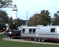
All units left camp within a 15 minute time slot, beginning at 7:30am, for the fifteen mile ride up to Port Huron. At the drivers meeting the night before, we were paired with Frank and Sally Magalski to travel together as our "New Best Friends." They are from Maryland. We all parked as a caravan at the Port Huron Municipal Marina where a trolley picked us up for a tour of the Lightship Huron, the Fort Gratiot Lighthouse, and the Thomas Edison Museum - all interesting places.
A lightship is a floating lighthouse, anchored in areas where a light was needed, but too deep or otherwise impractical to build a lighthouse. The Huron was anchored about six miles north of the Port Huron in Lake Huron during the shipping season - when the lake was not choked with ice. The crew of eleven worked 21 days and were off 7. While on duty, they had to ride out every storm that came along, often with twenty foot high waves crashing over the deck. The lightship is now grounded in the Port Huron harbor, restored as a museum - replaced in the navigation system by modern GPS systems. Our guide was animated and knowledgable, bringing the story of this bygone era back to life.
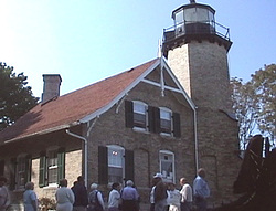
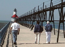
The Fort Gratiot Lighthouse, still a part of the Coast Guard system, was off limits because of the tragic events of last Tuesday. We were able to walk through an adjoining park to the waterfront for a good view and some pictures. It was a gorgeous day for picture taking.
Port Huron was the boyhood home of Thomas Edison. This is where he conducted his first experiments, supporting himself by selling candy and newspapers to train passengers. The museum is set up in the old Fort Gratiot Depot which is now called the Thomas Edison Depot. It's located almost underneath the Blue Water Bridge which spans the St. Clair River and provides road access to Canada.
The trolley took us back to the marina where we had lunch in the trailer, then started the drive up SR35 (M-25) to our camping site for the evening at the Point Aux Barques Lighthouse. On the way we made stops at the Port Sanilac Lighthouse and the Harbor Beach Light. Port Sanilac Lighthouse is now a private residence and unaccessible, but can be viewed from a pier on the lake side. We walked the half mile to the pier's end where several fisherman were trying their hand at salmon fishing. The Harbor Beach Light is a squat tower located on an offshore island, but was clearly visible from another long pier. It is still operating and still guiding vessels into and out of Lake Huron.
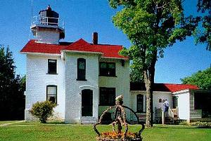
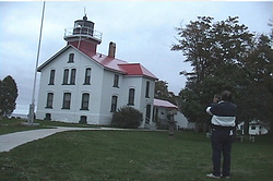
Total travel for the day was just 87 miles. The campground at Point Aux Barques was a beautiful spot directly on the Lake Huron shoreline and almost at the foot of the Point Aux Barques Lighthouse. The lighthouse, located on the tip of Michigan's "Thumb," was built in 1848 to guide vessels into Saginaw Bay and is still operating. From our trailer we looked out on Lake Huron which at this point stretches as far as the eye can see. The lake was calm on this day, but the shoreline is rocky and steep, obviously having been eroded by many storms. The water is clear and fresh. Everyone would liked to have stayed longer at this beautiful and relaxing place.
The drivers meeting in the evening was on the grounds beside the Poast's motorhome. Work assignments were passed out, and some changes were made to the itinerary, then cake and cider were enjoyed by all.
Tusday, September 18, 2001
We followed M-25 westward along the northern coast of Michigan's "Thumb," then southward through farm country to Bay City. The weather was clear and cool - about 60 degrees. We stopped for a sumptuous breakfast in Port Austin at the Lighthouse Cafe. From the pier at the marina there, the Port Austin Lighthouse was visible in the distance. As might be expected, the coast is mostly a resort area with many vacation houses built along the wide and sandy beach. The farming area appears to be a prime producer of sugar beets. Cornfields, probably a crop rotation feature, also checkered the landscape. The corn looked very poor, evidencing what must have been a very dry summer. We travelled 82.5 miles before reaching our campsite for the evening - the Bay City State Recreation Area.
We visited the Bay City Museum in the afternoon. The story was told there of the sugar beet industry in Michigan, as well as the story of maritime activity on the Great Lakes. As museums go, this one rated maybe a 3 or 4 on a scale of 10. The rest of the afternoon we were free to do as we please or just relax. We did the latter.
Wednesday, Septmeber 19, 2001
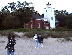
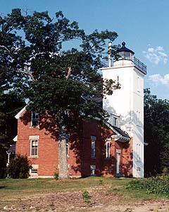
It warmed up considerably during the night and was raining lightly in the morning. We carpooled in the rain to the Saginaw River Lighthouse. This one is surrounded by land owned by Dow Chemical.Company. The lighthouse is about 125 years old and in sad condition. It is being restored by a local historical group. A representative from that group met us at the Dow Chemical gate to let us in and conduct the tour. Under normal conditons we would have been able only to view the light from the outside, but with the rain our tour guide took us inside even though it was all torn up for reconstruction. The tower was tapered with a square cross section and has a spiral steel staircase ascending to the top. When the reconstruction is finished, it will be a neat looking facility.
We were back at the campground by 10:30am hooking up and preparing to leave on the next leg of the journey - a short run (65 miles) to Tawas Point State Park.. It rained most of the way as we moved northward along the western shore of Saginaw Bay. One stop along the way was at Wilson's Cheese Factory. We bought a few knicknacks and an ice cream cone. Bill and Patt Herzing came down to ask if we'd like to walk with them to the lighthouse - about a mile down the road. The Tawas light is still in operation, managed by the Coast Guard. It is now automated and deserted, but still a very picturesque structure. The 70 foot conical shaped tower is connected to one end of the keeper's house by a bricked passageway. All doors were locked so there was no exploring inside. Upon returning to the trailers, we played Joker with the Herzings - the men winning 2 of the 3 games.
Then it was time for supper. We piled into Bill's Suburban and rode down to a beach pavilion where our caravan cooks had prepared a lasagna cookout. The rains came again during the meal, but we were well sheltered. The beach here was extremely wide - maybe a 1/4 mile. The wind had picked up, and the waves were crashing. It was hard to realize that this was just a lake - not the ocean. We were told earlier that the Great Lakes contain almost 20 percent of the world's fresh water.
Thursday, September 20, 2001
The rain had stopped, but it was still overcast as we pulled away from camp early - 7:30am - heading north to Sturgeon Point. This 70 foot tall lighthouse was one of the most scenic we've seen so far, and the keepers cottage has been fully resotred by the local historical group. There was no parking lot large enough for thirty rigs, and the lighthouse was at the end of a dead end road, so we all had to drive down, turn around by backing into a side road, then head back out, parking along the shoulder. It was then a 1/2 mile walk to the lighthouse.
We split into three groups to tour the lighthouse, an old one-room schoolhouse, and the gift shop in separate shifts. The lighthouse keepers cottage is a museum telling the story of the light and life on the lake during the late 19th century. There were stories of storms, shipwrecks, the fishing industry, and the lighthouse keepers.
Sturgeon Point was named for the large numbers of sturgeon that spawn in the area each year. A sturgeon is an almost prehistoric fish that grows to huge dimensions - some to 10 feet in length. They were almost extinct due to heavy fshing, but now protected, have lately made a comeback.
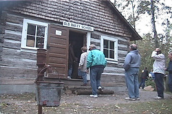
The little one-room schoolhouse, called the Old Bailey School, had a peak enrollment of 13 students in its day. Our guide told of how local schools bring their kids out a few at a time for a day each year for lessons taught the old way. The lady doing the teaching on those special days was actually a student in the old school when she was young.
Our next stop was at a Burger King for lunch with Paul and Dot Emmick, following which we continued on to Salena with its two small lighthouses - one green and one red. They were a short distance offshore, but could be seen from the marina. The lighthouses were unimpressive, but the town of Salena was very nice - lots of parks and playgrounds, and a beautiful marina. It must be a beehive of activity on the waterfront during the summer months.
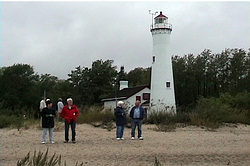
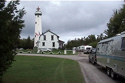
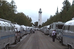
From Salena we proceeded on to Presque Isle, our destination for the evening - a 91 mile day. Presque Isle is pronounced by the locals - Pres-keel'. It stems from the French and means "almost an island." The original spelling on old maps was Presq' Ile. Our leaders had obtained permission to park the caravan for the night right at the lighthouse since the nearest campground was eight miles away. We parked bumper to bumper on both sides of a narrow park road. Standing at the end of the road, looking back, the lighthouse was framed by the two rows of trailers, an unusual picture.
At Presque Isle there are two lighthouses - the old and the new. Both towers were open and could be climbed. There were 33 steps in the old one, 127 in the new. I counted them. The keepers houses at both have been restored, and are now museums. The new light is a beautiful structure with a circular cross section. A cast iron spiral staircase ascends to the top where a balcony circles the light itself. The old lighthouse was built in 1840 and gave 30 years of service before being replaced by the much taller new light in 1870. The new one, now electrified and automated, is still in operation.
Soon it was time for dinner, and our leaders had ordered a catered meal delivered and served in a large sheltered room near the new lighthouse. It had begun to rain again, but that didn't matter. The thick smoked pork chops, baked beans, potato salad, cole slaw, rolls, and coffee made for some fine eating. Following that a lady from the local historical society gave us a talk on the history of the area and the lighthouses here. By the time that was done it was nearly time for President Bush's speech, so we all dispersed to our rigs.
Friday, September 21, 2001
Our destination for the day was Mackinaw City, 86 miles away. But first there was a stop at Rogers City, breakfast at Karstens Cafe and some shopping at Plath's Meat Market, the caterer for last night's dinner. Not far down the road was the 40 Mile Point Lighthouse, one of the neatest and most photogenic lighthouses along the coast. Parking the caravan along a one-way road was another challenge met by our leaders. This light was atop a square tower built adjacent to a two story brick keepers house. Again, we were able to climb to the top - some 53 steps. On the beach a short distance away are the remains of a shipwreck - just one of 27 ships that went down in a single storm in 1905. The water of the lake is amazingly clear. Rocks of all colors could be seen on the bottom.
Most of the lighthouses we've seen were equipped with a Fresnel lens (pronounced Fray-nell') to magnify the light. This is a glass globe shaped with an array of prisms that concentrate the light beam in one direction. They once magnified a flame, but now it's a tiny halogen bulb. With this magnification, the tiny light is concentrated in a way that it can be seen up to 20 miles away on the horizon. The lens at 40 Mile Point is a "4th order" lens. The smaller the order number, the larger and stronger the lens. This lens was manufactured in 1872 and has an antique value of more than a million dollars. New, it cost $12,000.
Each lighthouse has its own signature. The 40 Mile Point Light is on three seconds and off three seconds. Another might be on two seconds and off three, etc. Some are different colors - red, green, white, etc. Navigators on the ships have a "light" book and can determine where they are by triangulating on the lights they identify by the light's signature. They still use this system with the lights that are still operational as a backup to the modern GPS procedures.
Further along was an overlook where two small lighthouses were visible off shore.
We pulled into the Mackinaw Mill Creek Campground for a three night stay a little after 2:00pm. The beautiful Mackinaw Bridge which connects the upper and lower peninsulas of Michigan was clearly visible from our campsites.
A WBCCI Airstream Caravan called Lighthouse Color that started on the southeastern side of the lower peninsula of Michigan, then followed the coastline counter-clockwise to the southwestern side. The leaders:
Frank and Yvonne Rising
Gene and Sandy Poast
Thirty Airstream trailers and motorhomes rendezvoused at the Thousand Trails Campground in St. Clair, Michigan on Sunday, September 16, 2001 to begin the colorful trip.
Saturday, September 22, 2001
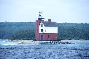
We boarded a shuttle bus at 8:15am for a short ride to the ferry docks in Mackinaw City. There we boarded a speedy shuttle boat for the 18 minute ride to Mackinac Island. The rooster tail thrown up behind the boat as it sped over Lake Huron in the early morning light was a startling sight. The weather was perfect - clear, sunny with mild temperatures. And guess what! - another lighthouse - two, in fact. The old light is the Round Island Light, a barnlike structure on a little rock island. The newer light is an unpretentious cylinder marking the channel into Mackinac Island.
Mackinac Island continues to be like a step back in time - no automobiles on the streets - only horses and bicycles. On this occasion the boy scouts were there in large numbers - 1,000 or more. With the Emmicks and Magalskis we rented a private horsedrawn carriage for a tour of the island. The driver took us down the road in front of the Grand Hotel, the Governors Mansion, the golf course, the old fort, and through much of the residential neighborhood - summer homes worth millions.
The Grand Hotel is the dominant building on the island. It was built in 1887, and lives up to its name in grandeur and elegance. Room rates range from $250 to $450 per night, and hamburgers cost $8.00. The front porch is the length of two football fields - 600 feet long. It now costs $10 just to enter the place.
At the end of the carriage ride, we walked up to the old fort for lunch in the Mackinac Tea Room. Eating out on the terrace gave us million dollar view of the harbor and Lake Huron beyond. The girls enjoyed some shopping downtown after lunch, then we reboarded the launch for the trip back to the mainland.
Sunday, September 23, 2001
This was a free day for the caravan - a day to rest and relax and do as we pleased. With all tragedy of September 11th still on everybody's mind, it was a day for both physical and spiritual renewal - a day to reflect on our values and priorities. A day perhaps to mourn our losses and be doubly thankful for all we have left.
The rain was back as we awoke - the temperature in the high 50s. Yesterday on Mackinac Island was a bright memory. For the first time in awhile, we were able to get our satellite dish positioned. So, the TV is telling us that it is raining back home too.
One of those pleasant coincidences came about when we heard from Jerry and Emmy Muller that they were coming to Mackinaw City for a three day stay on Mackinac Island. After an exchange of emails and cell phone numbers, we received a call from Jerry in the afternoon that they would be in town in time for dinner. So, rain or no rain, we drove in to their hotel to join them for dinner. It was great to see them and compare where we had each been since last seeing each other.
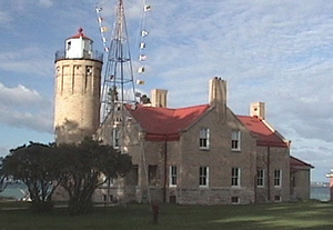
After dinner we drove over to the Old Mackinac Point Lighthouse at the foot of the Mackinac Bridge. The Lighthouse was closed for restoration, so there was no way to go in, but it was in an especially beautiful setting with the lake and big bridge in the background.
Monday, September 24, 2001
The rains had abated, but as this day started the wind was up, kicking up white caps all over the lake. Doughnuts and orange juice were out for anyone braving the elements to go get them from our leaders trailer. The skies to the northwest looked clear, giving some promise for improvement. The temperature was in the low 50s.
Our convoy of Suburbans left the campground at 10:15am for a 100 mile circular tour of the shoreline of Lake Michigan. The Nortons (Charles and Sue) and the Magalskis (Frank and Sally) rode with us. Our first stop was at Cross Village and the home of Legs Inn, a unique Polish restaurant on a bluff overlooking the lake. The stone structure is topped by inverted legs of old wood stoves - hence the name Legs Inn. From the beautifully landscaped back yard, four lighthouses could be seen offshore - White Shoal, Gray's Reef, Skillagalee, and Waugoshance lighthouses. However, they could only be seen clearly with binoculars. The wind was brisk and cold, and widespread white caps covered the lake. The caravanners didn't linger long in the wind before finding their way into the restaurant where we had a Polish lunch. It's difficult to describe what we ate - sort of a large dumpling filled with shredded cabbage maybe, and a couple of small stuffed things. Found out later that these things were called Golabki and Pierogi. Had the weather been better, we would have been served out on the terrace. All the furniture inside was handmade and very unusual.
After lunch we continued down the lakeshore along the top of a bluff and through a forest of hardwoods. It was a nice drive, though expected fall colors were not yet in evidence. Our next stop was at Harbor Springs a neat little town on a natural protected harbor. From the number of boats in the marina, this is a active summer resort town on the lake.
From Harbor Springs we moved on to Petoskey State Park where we wandered the beach for a few minutes looking for Petoskey stones, a fossilized stone unique to this area. A few of our folks found them. They are smooth gray stones with dark round spots that look like eyes.
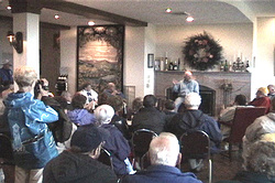
From there we proceeded to Bay View - a Chattauqua community established back in 1870, where we were treated to a walking tour conducted by the owner of the Terrace Inn. There are 439 houses (called cottages) in the village, all upscale and most built before 1920. The houses are owned by individuals, but the land is leased and controlled by the homeowners via the Bay View Association. It's a summer community, and all must leave by November 1st each year. The community activities include programs of cultural, educational, or spiritual values. The Terrace Inn is a bed and breakfast inn that was built in 1911. It still has most of its original furnishings. After the tour we were treated to coffee, punch, and cookies in the dining room. This was one of those things which was very interesting and something we would never have known about without the caravan.
The town of Petoskey was just down the road from Bay View. We were on our own for the rest of the day to shop Petoskey and travel back home. The sun was out, so back in Mackinaw City we stopped by the Old Mackinac Point Lighthouse for pictures.
Tuesday, September 25, 2001
This was the day the caravan moved from Mackinaw City to Traverse City. The wind was still brisk, skies overcast, and the temperature down to 45 degrees. We could see traffic on the Mackinac Bridge just barely moving as the vehicles carefully made their way across. Our usual travel companions had special assignments on parking and other things, so we traveled down US31 by ourselves. Our first stop was at the Charlevoix South Pier Light. There was nothing unique about this light except the waves crashing around it. The wind was probably up to 40 mph.
Charlevoix is an upscale resort town with many fine homes. Leaving the lighthouse, we passed a number of stone houses, including one called "The Mushroom House," a round house with an undulating roof.
The further south we got, the nastier the weather became. It was raining hard when we arrived in Traverse City. The caravan parked on the fairgrounds south of town. Traverse city is known as the cherry capital of the world. The cherry harvest was over, but there were all sorts of cherry products available. We were treated to icecream and cherry pie later in the evening in a nice meeting room at the fairgrounds. Following that, several games of Joker were enjoyed. We played with Frank and Yvonne Rising, and Jim and Irene Holton.
Wednesday, September 26, 2001
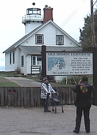
The Old Mission Point Lighthouse is located almost on the tip of the Old Mission Peninsula which extends from Traverse City northward into Traverse Bay. The lighthouse is exactly on the 45th parallel, halfway between the equator and the north pole. It's now privately owned as a summer home, and appears to be in excellent condition. The beach is strewn with rocks of all shapes and sizes. The lake level is down six or eight feet below normal leaving exposed rocks of all shapes and sizes out a hundred yards or more.
The caravan carpooled out to the lighthouse. We rode with the Magalskis this time. The weather was no better, raining through most of the trip. We seemed to be right on the edge of a low pressure system that just wouldn't go away. The temperature was in the low 40s. but the wind wasn't as bad.
On the way back we stopped at a winery - the Chateau Chantal - where the winemaker, Mark Johnson, gave us a lesson in wine tasting. The climate on the Old Mission Peninsula, moderated as it is from the deep water of the lake on both sides, is proving to be ideal for growing the variety of grapes used by this winery. They are small in relation to their larger competitors in California, but devoted to quality. Most of their wine is sold right from the premises to tourists like us. The Chateau is also a bed and breakfast.
From the winery we had lunch as a group at the Peninsula Grill, then returned to Traverse via a shoreline road. There are many fine houses on the western side of the peninsula.
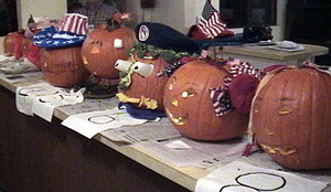
In the evening we gathered again at the meeting room for pumpkin pie and a drivers meeting. Following that there was a pumpkin carving competition. Eight pumpkins were carved and decorated to the delight of the group. The winner had plastic cups for eyes, broccoli spears for hair, pumpkin slices for ears and mouth, and a Wally Byam hat to top it off.
Thursday, September 26, 2001
The Grand Traverse Lighthouse, authorized in 1850 by Pres. Millard Fillmore, sits on the tip of the Leelanau Peninsula marking the entrance to Grand Traverse Bay. The Leelanau Peninsula is called the "little finger" of Michigan's mitten. The lighthouse is no longer functional, but houses a museum that tells Michigan's history. Much of the original furniture that belonged to the keepers has been returned to the house. This was probably the most elegant of all the lights we saw - beautifully furnished. The 45 mile drive to the Grand Traverse Light follows the lakeshore along the west side of the west arm of Traverse Bay. We drove in the carpool with the Magalskis and Nortons.
On the return trip we stopped at the Christmas Cove Farm Market, an unusual place where they advertise "antique" apples. An antique apple is one of the early varieties that existed in bygone days. The list includes Rhode Island Greenings, Duchess, Wolf River, Winter Banana, Snow, and many more. They had gift boxes made up with sixteen different antique varieties. This farm has been honored by the Historical Society of Michigan for preserving these old varieties. The owners also had a collection of over 7,000 pop bottles, all displayed on the walls of their market. Antique lard pales hung from the overhead trusses. They had 240 varieties of apples growing on the farm.
At 5:00pm we all went to Boones Long Lake Inn for dinner. We were warned ahead of time to split the dinners because of the generous portions. We ordered prime rib, shared it, and still brough leftover meat home. It was a feast.
Friday, September 28, 2001
We left the fairgrounds about 8:30am in another carpool to visit the coast of Lake Michigan and several sights along the way. The first stop was at an unusual place called Gwen Frostic Prints. This was a printing business, but was also a tribute to nature. Gwen Frostic was a lady artist who made her love of nature and art into a profitable business. The building is constructed from large native rocks topped by a sod roof. The printing presses produce cards, books, wrapping paper, stationary, calendars, napkins, placemats, etc , all printed with Gwen Frostic's artwork. She died last year, but left the business to a foundation that continues the business and the atmosphere of the 250 acre wildlife sanctuary. Huge old weeping willows shade a portion of a pond behind the building.
The next stop was at Frankfort and the Frankfort North Breakwater Lighthouse. This light is at the end of a breakwater pier, square shaped and about two stories tall. It was possible to walk to the light on the pier, but most of us were satisfied to view it from the wide beach next to the parking lot. This was not the prettiest of lights, but still functions.
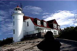
Next, we stopped at the Point Betsie Lighthouse. This was the last light on the Michigan coast to be manned by a human keeper. It was not automated until 1983. The light is still owned by the Coast Guard and is not accessible to visitors. The light tower is attached to a large two story house that housed two familes when the light was manned. The structure was well maintained and one of the prettiest we've seen.
Next, we stopped at the Robert Manning Memorial Light. This light was erected by the family of Robert Manning, assisted by the township of Empire, Michigan. Robert Manning was a well liked local resident who fished in Lake Michigan. He always wanted a light to guide him back home. When he died in 1991, the light was erected in his memory.
By now we were ready for lunch. The Friendly Tavern in the town of Empire was ready with soup and sandwiches. Afterwards we headed for the Sleeping Bear Dunes National Lakeshore. At this point the shore of Lake Michign is lined with huge sand dunes. The largest dune rises 460 feet above the water in a steep wall of sand. We climbed to the top on a boardwalk for a grand view of the lake and shoreline. The clouds had moved out, the skies were a vivid blue, and the air was crystal clear. Details on two islands about five miles out from shore could be easily seen.
At this point the carvanners scattered for the trip back to camp. We took the scenic route along the north side of the Leelanau Peninsula, stopping at a famous sausage making facility called Pleva's Meats. They used local cherry juice to add a distinctive flavor to their sausage. Recognizing that he had a great many potential customers, the owner fixed a batch of samples for us to taste. His cash register rang with gusto, recording the sales.
We made it back to the fairgrounds about 6:00pm after some 10 hours on the tour. After a drivers meeting, we played Joker again until bedtime.
Saturday, September 29, 2001
After a "boil-in-bag" omelet breakfast prepared by the caravan cooks, the caravan moved from Traverse City to Ludington, Michigan. On the way we made one stop in Manistee to see the Manistee Pierhead Lighthouse. It was a metal clad tower located at the end of a long pier.
We were the caravan caboose on this move, and therefore the last to arrive at the Western Michigan Fairgrounds in Luddington. The job of the caboose is to give each unit a safety check as they depart, then stop to give assistance to anyone with a problem on the trip. Fortunately there were no problems on this short, ninety mile move.
Luddington is a fair sized town on the western coast of Michigan. After getting set up we drove to the lakeshore to see two more lighthouses - The Ludington Pierhead Light and the Big Sable Light. The first was very similar to the Manistee Pierhead Light, a metal clad tower at the end of a long pier. The second was a beautiful lighthouse located in Luddington State Park about seven miles north of town. The only hitch was that it required a 2 mile hike to get to it.
We set out for Big Sable about 3:30pm. Just before entering the park, we crossed the Big Sable River. Cars and pickups were parked bumper to bumper along the side of the road. When we crossed the river, it was obvious what was going on. The salmon were runing. Fishermen were almost shoulder to shoulder, wading in the river casting into the school of fish. We could see the thousands of fish, even without getting out of the truck. There was no place there to stop for a better look, so we continued on into the park. The ranger at the gate told us where to park and begin the hike to the lighthouse.
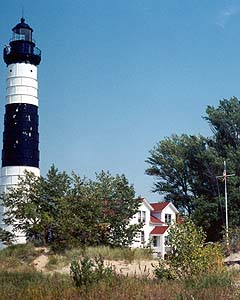
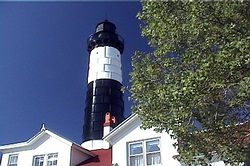
We walked through a crowded cmpground to the trailhead where a sign pointed toward the beach and to the light. The trail was level and wide, but there were many spots where the sand was deep, and it was hard walking. Sand dunes blocked our view of Lake Michigan, but we could hear the surf on the other side. Before long we could see the top of the lighthouse, then the whole thing. It was a beautiful conical shaped tower, painted white with a wide black horizontal stripe in the center. It adjoins the old keeper's house. When this light was operating it had a 3rd order Freznell lens. That lens is now in a museum in town, but efforts are being made to get it back into the lighthouse where it belongs.
The keeper's house was again a museum and gift shop. Profits go toward maintenance of the structure. This was one of the nicer ones, and the beautiful blue skies made photographing it a pleasure. I climbed the 130 steps of the spiral staircase to the top, rewarded by a fantastic panoramic view of the lakeshore north and south. We, of course, then had to walk the two miles back out, and by the time we reached the truck, we felt we'd earned a stop at the local Dairy Queen.
Frank and Sally came over later and gave us a lesson in playing cribbage to end the day.
Sunday, September 30, 2001
Another free day. The skies were a brilliant blue in sharp contrast with all those rainy days before. The temperature began about 39 degrees, but rose quickly to the low 70s when the sun came up.
After lunch we drove back out to Ludington State Park. The salmon were still milling around the bridge over the Big Sable River. Some of the salmon visible in the water were huge. I took some pictures this time as some of the fish were snagged. None of the fishermen that I saw were able to bring the fish in before the line broke. We went to the Great Lakes Visitor Center and saw a movie about Big Sable Point, once a lumbering center, but now returned to nature. I climbed about 100 steps up to a boardwalk along the top of the dunes called the Skyline Trail. The views across the dunes were good.
Ludington is the port for a car ferry that crosses Lake Michigan to Manitowoc, Wisconsin - a four hour trip. The ferry coming in, as many of the caravanners watched, had to be towed to port. We never learned why. There was an Airstream trailer at the port being used by the Coast Guard Auxiliary.
We all ate dinner together at the Old Hamlin restaurant in Ludington. The meal of roasted chicken, dressing, mashed potatoes, string beans, and homemade bread was very tasty. Back at the fairgrounds we met for dessert and a drivers meeting. Following the drivers meeting I showed my Caravanning with WBCCI promotional tape.
Monday, October 1, 2001
Four lighthouses today - two at the Pentwater pier, the Little Sable Point Light, and the White River Light. The Cookes (Bob and Virginia) and the Magalskis rode with us in the carpool. The first two lights were markedly without charm. One, a skeletal structure painted red, was located on the end of a pier on the south side of the channel; the other a cylindrical tanklike structure painted white and green, located on the north side of the channel.
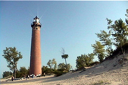
The Little Sable Point light was another thing altogether. This sone was a tall (100 feet, plus) brick tower on the beach, built in 1873 with a third order Fresnell lens. The brickwork was exquisite, making this one of the prettiest towers we've seen. It's taller than the Big Sable light. Unfortunately, the keepers house was torn down by the Coast Guard because of severe vandalism after the light was automated. We did see pictures at White River of the original installation. It's a shame it's not still there. We were met at the lighthouse by two ladies who are part of a movement to preserve the light tower itself. After we had walked the beach for several minutes, the ladies had donuts and cider waiting for us at our cars. Hoping to get a government grant to rebuild the keepers house, they are raising funds any way they can. They didn't ask for donations, but a good many of the caravanners threw a couple of dollars in the box.
The White River Lighthouse is at the mouth of the White River Channel that connects large White Lake with Lake Michigan. This light tops an octagonal brick tower which is an integral part of the keepers house. It is now a museum with a full time curator. This light was built in 1875, partly as a result of the Great Chicago fire in 1871. Lumber became a much needed resource after the fire, and the White River/Lake region was an excellent source. Barges and sailing vessels coming into the channel needed the light to guide them past rocks on either side of the channel. This light is not so tall, but evidently was effective in reducing shipping accidents when storms kicked up the lake. The White River and Little Sable lights were once painted white over the bricks, but have now been sandblasted to expose the beautiful brickwork in its natural color.
We learned a couple of things from the young lady who was the curator. First, a formula for determining the distance a light is visible across an expanse of water. Visible distance in miles = 1.144 times the sum of the square roots of the height (in feet) of the shore light and the height of the bridge on the ship.
The second interesting thing we learned was that the oldest lighthouse in the United States is in Boston Harbor, established in early 1700s. That light also has the distinction of the being the only light left still operated by a human lighthouse keeper. That will change at the end of this year when he retires. It can then be claimed that Boston Harbor light will be the first and last to be maintained by a human keeper.
On the way back to Ludington we stopped in the village of Montague to see the "World's Largest Weathervane" and to eat lunch. Guessing at its height, I would say the vane is maybe 40 foot tall with a 20 foot long arrow at the top to show wind direction.
Another stop on the way back was at the Shelby Gem Factory. Simulated gem stones, including diamonds, sapphires, amethyst, rubies, topaz and others, were being created with high pressure and temperature. We were told that experts had difficulty telling the difference between these and real stones. I sure couldn't tell the difference. Prices were probably about 90 percent less than those of the real thing.
We arrived back at the Ludington fairgrounds about 4:00pm.
Tuesday, October 2, 2001
It was moving day again - this time from Ludington, through Muskegon, to Grand Haven State Park - about 82 miles. On the way we visited the Muskegon South Pier Light, guarding the north side of the channel from Lake Michigan into Muskegon Lake. This light was first installed in 1851. It's a conical shaped tower clad in steel and painted red. On the south side of the channel is a taller, more utilitarian light - ugly. We walked the quarter mile out to that one before proceeding on to Grand Haven.
Grand Haven State Park is right on the beach, and we were parked right in the sand - sand that had blown up on the pavement of the parking lot. Just as we arrived the fog rolled in off the lake. We had to just take it on faith that the lake was out there. The expanse of sand was immense. The Muskegon Channel was just south of the park. It was a fairly easy walk over to the channel and out to the Grand Haven Lighthouse near the end. By the time we got set up, the fog had moved out, and we found that we were in a beautiful spot.
Grand Haven is a boat lovers paradise. Sailing, fishing, small motorboats, and large yachts were in abundance. We drove into town where the main street is lined with gift shops and touristy places. A parade was forming to express support for America. American flags were flying everywhere.
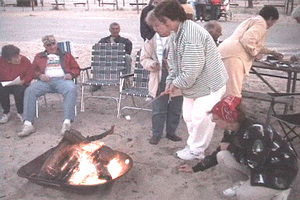
By the time we got back to camp, our caravan cooks had a soup and sandwich supper ready. We enjoyed the meal on picnic tables on the sand. We watched the sunset later, then roasted marshmellows over a roaring campfire.
Wednesday, October 2, 2001
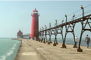
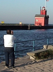
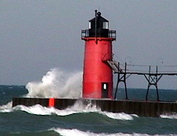
We had parking duty on this day, so left Grand Haven with three other units, moving down to Benton Harbor, our last stop. It warmed up considerably - 62 degrees at daybreak, but the wind picked up during the night to almost gale force, really kicking up the lake and blowing sand everywhere. Our first stop was at the Holland Harbor Lighthouse, called "Big Red" because of its barnlike appearance and bright red color. Big Red guards the south side of the channel leading from Lake Makawawa to Lake Michigan. The waves were breaking over the seawall sending spray 20 feet into the air. A lone windsurfer was out doing his thing.
Our next stop was at the South Haven South Pier Light. This is a conventional shaped tower, clad in steel and painted red. It marks the entrance to the Black River. A catwalk extends from shore to the second story of the light. This allowed the keepers to reach the light even in stormy weather.
As we came out of Grand Haven, Paul Emmick was the first to spot the "mystery" lighthouse. Our leaders had taken a picture of this light the previous year and placed the picture in the drivers manual. The first person to spot it got a prize. It was on the front lawn of the Best Western motel.
Then it was on to our last campground on the caravan - a KOA in Riverside, Michigan. When everyone was in, we rode with the Magalskis to Benton Harbor to see the St. Joseph Pier Lights. The wind was fierce, but we braved the elements to walk the length of the pier to the two lights. The wind was coming out of the south and had the temperature up to 82 degrees by mid afternoon. The first light has been in place since 1846. The second was installed in 1907. There is also an elevated catwalk on the pier for use when the lake was extremely rough with waves breaking over the pier. A ship coming into the channel could line himself up with the two lights. Both these lights are automated and still in operation. These lights are the first on the western side of Michigan's lower peninsula - and therefore, the last on our tour.
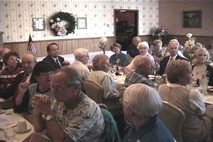
Our final banquet was at the Fireside Inn in Springville. Everybody dressed for the occasion in good clothes - first time. The meal was delicious. Some had shrimp stir fry; some had roasted chicken; others pork chops. We brought food home. Carolyn Place emceed the program and did an outstanding job. This was the "first" caravan for twelve couples, though some had been in the club for years. Each of these was asked to give their impressions and to tell of their most memorable moments. Some were funny; some were serious; and they all were sincere in their praise of the good time we'd had together. The most cited memorable moment was the story about how our leaders wives took the wrong boat back from Mackinac Island and wound up in St. Ingace on the upper peninsula. Frank Maglaski said his favorite thing was Sleeping Bear, but that Sally had made him wear pajamas the next night. Almost all had something to say about love of country and the freedom we enjoy in America - especially the freedom to travel - made especially so in our minds by the tragic attack on our country just before our caravan began.
The caravan leaders did a fine job of decorating the tables - miniature lighthouses every few feet, place cards each with a different lighthouse where we'd been, a program with pictures, book marks with scripture verses, and little stained glass lighthouses to hang in the window. It was one of the best final banquets we'd experienced. All agreed that we had learned a lot about lighthouses, their history, and their operation, We also agreed that the lakeshore of Michigan is unique and beautiful. The evening closed with everybody singing God Bless America.
Thursday, October 4, 2001
It was goodbye time on this morning as we came together one more time for doughnuts and coffee before pulling out and going our separate ways. We had made some new friends - especially Frank and Sally Magalscki. We had had a lot of fun and a great adventure.
So now it was time to head home. There was a little fall color in the maples, but very little in other trees. Good weather continued. We drove down I-94 to I-65 to I-74 to I-75 through Indianapolis and Cincinnati to Lexinton, Kentucky where we camped at the Kentucky Horse Park. This being our last night out, the travelog of this trip will end here.